John B. and I, had our sites set on Greylock for an XC flight. The night before conditions were predicted to be good so we decided to talk in the morning. The 'plan' was, get an early start since it's an east facing site. Morning came, and I could not reach John. He lives in a cell phone black hole and it was another hour or two before I finally heard from him. He said he was en-route to my place. I was finishing off making breakfast when I hear a knock on the door. John enters and immediately eyeballs my breakfast with a watering mouth and longing gaze. He comments on how good it looks.
That little white speck in the middle is John. :-D
So looking at the clock, with hesitation in my head, I offer to make him a couple eggs and he can throw in the toast. What's a few more minutes right? Backing up a bit, Jeff C. had called before all this to say he would like to go along. Jeff was still a ways out from leaving his house so we thought it best he take his own car. This was before a certain unprepared individual wanted breakfast, and a certain altruistic saint made it for him. By the time we were done eating and ready to pull out of the driveway, Jeff was 10 minutes out.
Ya, that's pretty far below...
"Ok", I said. We'll wait a few more minutes. We sat in the driveway waiting for Jeff to arrive. After loading up my car, we were finally ready to go. We set out for the 3 hour ride. On the way, we shared some good laughs on the questions usually asked by tourists when you're on top of Greylock. It's always the same questions.
Jeff needed a few laughs coming off of two wakes in the previous week so we came up with some pretty interesting responses to these questions. John and Jeff then decided it was a good idea to start harassing me for amusement. At one point, Tom called and said Mt. Washington looked perfect. John and I discussed throwing Jeff (a Hang III) out of the car and heading to Washington since we both wanted to fly that elusive site and you need to be a Hang IV. After much deliberation we decided it was too far back in the other direction, and decided to keep Jeff with us. He was allowed to close his door again.
The streets were alive.
As we approached North Adams, Pete J. calls and says he is at the RC field. He offers to bring us up with him if we want to throw on. It was another added delay, but my car is starting to revolt when it comes to hill climbing so it seemed like a good opportunity to keep my car at the bottom of the mountain. Pete was nice enough to offer, so we took him up on it. On the way up the mountain, Pete was sure to tell us that his daughter was NOT available for chasing us cross country, if we decided to leave the mountain. He likes to set things straight before any ideas get to far along.
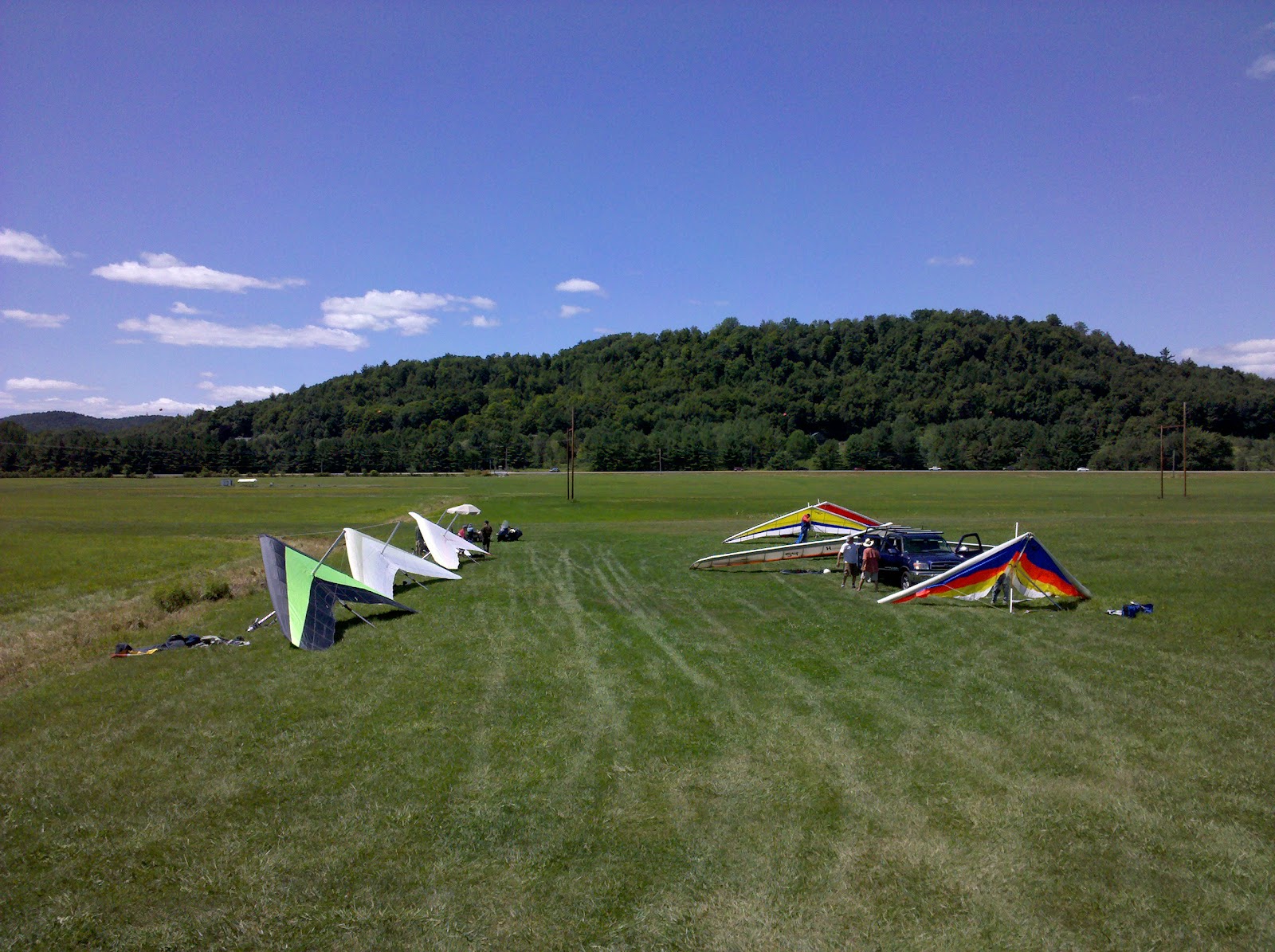
Harriman-West Airport
We arrived at the top of the mountain and the conditions were iffy. There was little to no wind on launch, and when there was wind, it was crossing pretty far from the south, almost 80 degrees. There were a bunch of pilots, hang-glider and para-glider, there to fly that day. While we were setting up, many jumped off to mixed and unimpressive results. A few climbed above the mountain and stayed up for 30 minutes or so. All eventually ended up on the ground.
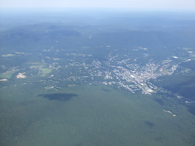
Williamstown
Pete launched around 1:15pm, and after finding no reason to stay on the ridge, did his signature disappearing act. Jeff and J-J were already on the ground after their extended sledders, and Gary was on launch with his para-glider trying to wrestle it up in the crossing winds. Gary launched and found a few thermals out in the valley, scratching through them trying to stay aloft. That left John and I to try our luck. I walked out to launch and sat for quite some time, in completely dead wind, waiting for some sign of lift out in the valley, that I could reach. The day was getting late (now after 2pm) for an east site but I was in no hurry to sled. It couldn't get worse right?
Looking South
About this time, Pete flies in from Ragged Mtn. reappearing out of nowhere. This is why I started calling him the Grey Ghost, the guy has a teleportation skill or something. Pete snagged a thermal about 300 yards from launch and took a turn in it. He was on his second turn and climbing, when I was lifting my glider. I heard my radio crackle - Pete was keying his mic as he was thermalling and said, "This is our ticket out of here Randy." I was already running down the launch. I took off into the calm air and as I passed over the rock slide below launch, I tried a small turn to the right testing the air to see if there was any lift coming up - nothing. I returned to course, zipped my harness, pulled my face shield, made myself small, and ran for Pete's thermal. This was exhilarating as it was the first time I had ever launched a mountain site with no wind trying to get a thermal out in the valley.
Looking back on Mt. Greylock
I came in right under him and snagged it. We climbed out together as John moved to launch. We reached maybe 500 ft. over launch and the thermal was gone. We spread out and started searching for lift again, and fast. I headed to the south side of the mountain since the wind was cross and the sun was on that face. John decided there was no reason to rush into the air and waited on launch. Pete and I found a few more thermals to get us back to the same point, but they would disappear again and again. On another climbout attempt, Pete decided to disappear again and head out into the valley. I turned around and he was gone. No trace. No word.
Quarry and Adams, MA
I continued to do the yo-yo up and down above the mountain for almost an hour. In the meantime, John finally decided to give it a try and joined me above the mountain searching. After snagging one, he decided to head for a cloud far to the south that was out of my reach. I lost sight of him after a few turns and did not find him again. I figured he was on the ground after trying to reach him on the radio with no response.
North Adams, MA
I was on my own. Ah well, I'm good with that. I played around on the mountain a bit more and then I decided to try my luck out in the valley. I headed toward Ragged Mountain where I snagged a small 100fpm thermal and started to climb. A para-glider that had launched shortly before that, ran to the thermal and tried to claim it as his own. I was having none of that, and held my ground. I kept circling tight and climbing and he bugged off to find something else back on the mountain. I stuck with the slow climb, drifting downwind very slowly (3mph) as I climbed above launch, and then above the mountain.
Looking North
I finally broke through the inversion layer and the thermal picked up strength. I was now climbing in 600 to 800fpm up. As I'm shooting up to the clouds, I see a glider come in from Ragged Mtn, it was the Grey Ghost again. "Geesh", I said to myself, "I thought he was on the ground an hour ago!" Pete was up to it again. He came in below me about 500 ft and scoured for the thermal. I tried to direct him via radio, but he just couldn't snag it. He gave up and headed off to find something else, I continued my ascent.
John's getting higher
Shortly thereafter I was at cloud base (6600') and drifting behind Raven's Rock toward Harriman-West Airport in Williamstown. There was a beautiful cloud street heading right toward Bennington, VT, and I was going to run it. As I approached the airport I was famished and needed sustenance. I cracked open a protein bar and wolfed it down as I buzzed around trying to stay out of the clouds.
About this time, I spot a glider about 3000ft. below me. It was a topless glider so I was running through my head who it could have been. I figured John was on the ground as last I saw him he was off in the other direction of launch and not finding lift. Although, I did remember that he wanted to at least land at Harriman-West if the day produced nothing else.
Bennington, VT in the distance.
Then my radio came to life, it was John -"Randy, where are you? Are you on the ground?" I laughed and responded - "Look up, I'm 3000ft. over your head." John was laughing but slightly annoyed that I was flying over him after he had assumed I was on the ground. I then said - "I have to pee, you don't mind right? Jeff told me you were into that sort of thing..." He laughed, and cursed me. I didn't do it.
I cruised around under the cloud waiting for John to catch up as he had found the climb (with a little help from a friend). As John ascended to 300ft. below me I made the jump down the street to the next cloud. It was still producing lift. John followed and we drifted slowly toward Bennington. Unfortunately, there were no more clouds after this one along the street. There were a few small cummies around Bennington but nothing well defined.
Lots of greeeeennnnn.
John contacted Jeff, who was trying to get a head start in the car following us. He told him we were almost to Bennington and heading NNW if he wanted to head out. John then dove into the blue, and shot for another cloud. I followed along watching his speed machine quickly fly away from me.
I lost about 3000' when I found a small thermal. I climbed in it gaining another 1000' and then I lost it due to a biological malfunction. After wasting precious altitude trying to find it again, I shot for a peak SW of Bennington that was higher than anything around it. As I approached, I found a few more ragged thermals but still couldn't break back through the inversion layer.
Valley East of Bennington
John was well on his way toward NY now and too far away for us to reconnect. I continued on my own and spotted an airport to the west. I started sizing it up as my potential and likely LZ. Before I made it all the way over to the airport, I found a small thermal to climb out in. I drifted to the north riding this ratty lift for everything it was worth. Jeff was holed up in Bennington waiting to see where we went.
John had headed into NY on the other side of the ridge north of Bennington, but we were now out of radio contact. I made a decision to head to that same high ground, but try and reach Mount Equinox, as John and I had mused about earlier in the day. I looked at the slopes and opted for trying to find climbs on the leeside of the ridge where the sun had been making the most contact all afternoon.
Bennington, VT
I snaked slowly to the north not wanting to give up the lift that I had. As I climbed up the terrain in and out of the thermal, I started assessing potential LZ's. I could head NW toward NY but I had another ridge line to cross before even seeing any LZ's. I looked at the ridge north of me, and the lack of available LZ's in the draws, but I was high enough to get over the back and hit an LZ along Rt. 7 if I didn't find anything. I went for it.
As I climbed up the ridge line getting closer to my goal, I was finding smaller and smaller thermals. I was now approaching the section of the ridge where I was either going to find another thermal to get me up, or I was going to have to dump over the back and bail for an LZ. I found a nice strong 600fpm thermal but it was the size of a bullet. I was turning and turning but losing just as much as I was gaining. I finally realized the day was quickly coming to an end. I bailed from the thermal and bombed over the backside of the ridge heading as far north as could glide.
Southern Vermont College
My available LZ's were all filled with corn. I would approach and see what I thought was hay, but was really the tips of the corn that have golden grass like sprouts rising into the air. I finally saw an LZ clear of corn but it was an iffy glide if I hit sink. I had one bailout field just to the south of it if things went wrong on the way. I tucked in, pulled VG, and went for best glide.
I made the LZ I wanted with plenty to spare and boated around for a minute or two before making my approach. The owner had mowed a bullseye in the field, which I later learned was an attempt at eradicating an invasive species. Perfect, a spot landing contest. I pulled in, turned on final, and glided into the bullseye for a nice touch down.
Bennington Monument
As I walked the glider to the side of the road, a friend of the landowner came across the road to chat it up. He invited me over for a refreshment after I was settled in. Lucky for me they were so welcoming as I pulled my phone from my harness to give Jeff and John (now out of radio contact) a heads up to my location, only to find my battery was dead. Uh Oh! Coincidentally, the landowner has a cousin that used to hang-glide and helped develop Mount Equinox as one of our flying sites back in the day.
The owners were kind enough to let me use their phone and even offered me some of their dinner, which I politely declined. After we talked a while they invited me to go dancing with them later that night. Also politely declined. :-) What a perfect place to land. Thanks!
Earthbound once more
I reached Jeff and John, John had landed in Salem, NY 11 miles further than me. Jeff was almost to him and after I gave them directions, it was going to be about an hour for them to trek back and get me. I finished my conversations with the landowner and friends, then broke down my glider while reliving my flight. I got enough juice back in my phone to text Tom (stuck in Alabama) the details of my flight. Turning the screw....
As I finished putting the bag on my glider, Jeff and John drove up in my car we loaded up. The landowners and their friends were leaving for the dance hall and waved us off. We stopped for dinner in Williamstown, laughed, told of our feats, compared notes, and shared a meal as only friends with a common passion can.
A day I will not soon forget. Thanks go out to Jeff for being one of the best XC drivers that day and a good sport for chasing us after such a short flight. We owe you one.
After a disappointing first flight, that ended with 40 minutes of air time and a few close saves. I was charged to get back in the air. Rodger F. and John Z had launched, climbed to cloud base, and were already heading to Newport going XC. I knew I was unlikely to catch up to them, but I wanted to get in the air ASAP. Dennis was also itching to go back for a second flight, and I figured we could head out together. Sean was up next in the launch queue, but Rhett had two tandems to tow up and Sean waited on the edge of the runway. I decided to suit up and get on standby, so Rhett could possibly tow up two of us in between tandems.
Pete J. was back on the ground helping on the runway after hitting 7700' and getting flushed with the rest of us. Dennis was giving the CT boys a hard time. They were over the back at 7700' and complaining that it was all sink back to Morningside. "Why did you come back?" Dennis asked. If they hadn't come back, they'd be at I-89 by now. I chuckled as Dennis said - "that's what we're TRYING to do!!! That's the point!!"
As luck would have it, for me anyway. Sean broke a weak link about 50' off the deck. He floated down and landed safely at the end of the runway. Out of Sean's misfortune, was born my chance to get in the air and redeem myself from the earlier defeat. I jumped on the cart as Dennis retrieved it, and off I went, airborne once more.
Rhett landing and Dennis burning off altitude for his approach.
Rhett waved me off at 2600' in a nice thermal (I waited a little longer on tow after the first flight ended quickly). I snagged the thermal and rode up to 3500'. I had trouble breaking through that altitude and couldn't figure out why. In review, I was falling out the back side of the thermal. I tried to jump to a cloud out in the valley where there should have been lift - nothing. I tried going back to where I snagged the first thermal, to see if another was lifting off - nothing. I sunk to just under 700' and found a thermal on the northwest side of Morningside.
I latched onto it, and rode it up to 4200' MSL. Dennis was out front and above me at this point, and I left my thermal and searched for what he was in, hoping for a better climb. But I couldn't find it, and instead went back to my own. I drifted over the back of Morningside at 4500' and headed toward Claremont. I found another thermal over South Claremont and rode it up to 4900'. At this point, I knew I had Newport Airport, barring any unforeseen 'demon sink'. I went for it. As I traveled, I went for the high ground, like Tom said in his XC seminar over the winter. A mistake I made last weekend with following the valley instead of the high ground on either side. Sure enough, I found a thermal over the cell tower and I climbed, riding it further west, closer to Newport.
I lost the thermal (again falling out the back), and decided to jump the valley to the north and position myself better for the airport. I went to the green on the north side and got lucky. I should have gone directly to the knob north of Claremont, or further west from my location to the higher ground - closer to Newport, and where a sailplane had been soaring a few minutes prior. I found a piddly thermal by Sullivan and took a few turns, fell out, and abandoned it afraid I would lose too much altitude trying to find it again.
I found a few small pieces of lift to turn in on the way to the airport. By now, I knew I had the knob, known as Colt Mountain, on the other side of the runways. I flew over the airport and sure enough, Colt Mountain was working. I followed a small thermal that built into a larger thermal after I gained a higher altitude. I followed the thermal over the quarry, and closer to Forbidden Field, now knowing I had that as an LZ, and could get an ice cream.
Been a busy flight. First chance to take a photo.
For a while I thought about landing there (ice cream is a convincing argument), but then in the back of my head, I heard John from earlier in the day saying, "people are going to do amazing things today". So I ponied up, and went toward the north end of Lake Sunapee, further away from Forbidden Field. I had an ice cream there last weekend anyway.
There were a few bailout LZ's I could get into if needed, but what I really wanted - was to jump the lake. As I hit the north end of the town of Sunapee, I found another thermal and rode it up to 4500'. I could not break out of the 4500' ceiling in any of these thermals, and began to think there was a layer keeping me down. I was getting frustrated after hearing that others were hitting 7700' to 8000'. I have not been that high, and I was hoping to break that personal record today. Onward I went, further north.
Forbidden Field in the distance. I decided to leave her behind and go over the lake to the North.
Now I was on a mission. I wanted to beat Rodger's flight distance, beat my personal best (set the previous weekend at 13 miles), and break out of the '0 to 25 mile' class for the XC competition. So I took the plunge and jumped the lake. I found some lift over the water, took a few turns, then decided I should stop playing in something too small to turn in, and get on toward my new destination - New London. As I reached the intersection of I-89 and Route 11, I found a strong thermal and tore up at 600fpm to 800fpm. The average was 400fpm, but I was happy with that. So far through the flight, I had been working solely 50fpm to 200fpm.
As I climbed up, I tried once more to reach someone on the radio after having communication gear malfunctions the entire flight. I was able to get enough chatter out to reach John. I heard him come back over the radio that he was approaching the border of Maine at 8000ft. This fueled my desire to go further, and I rode the thermal up to 6100', and began setting my sights on Kearsarge. I fell out the back side of the thermal again (need to fix that). As I soared over New London, trying to make myself as small and low drag as possible, I spied two golf courses I could use as LZ's. I headed toward the one furthest away, and began preparations to scope it out and get my landing mode on.
Lake Sunapee. Getting ready to cross.
I hit the foothills of Mt. Kearsarge, silently hoping to find a thermal as I approached my landing zone. As I glided along, descending further and further, I snagged a 50fpm thermal about 1700' AGL off the deck. I turned and turned, committed to climbing over Mt. Kearsarge. It was my next mission. I rode the thermal higher and higher, and eventually it turned into a 250fpm up. Sweet! I soared up and up, and pretty soon I was over and above the mountain.
Another shot of the lake with Mt. Sunapee showing at the top.
Now I began looking for LZ's over the back that I could head towards. I was focused on where to go, seeing limited options, and fell out the back of the thermal (again, I really need to fix that), thinking at the time that I had reached the top since it was getting late in the day. I tucked, making myself tiny, pulled the bar in, and made a run over the back toward Andover where I saw a field in the center of town. Hoping the lush green color was not 'over my head' corn! If so, there was a baseball diamond nearby I could stuff into. Not ideal, but given no other options.
Sunapee Golf Course in New London. A possible LZ if I don't find lift soon.
I hit sink over the back of Kearsarge, that pushed me down quite a bit, and then I realized my altitude was even with the summit. I was soon going to be, or already in, the rotor from the mountain. I decided to get the hell out of there and scooted NW. I was now close enough to see my primary LZ was a soccer field. I approached Ragged Mt. and began scoping out the LZ in more detail - wire locations, obstructions in the field, and then looking for flags or wind indicators as I hit 1000' AGL. I originally intended a cross wind landing, the longer direction of the field, but after getting lower, I realized I could land sideways and directly into the wind. So I set up for that approach, and burned off my altitude.
Mt. Kearsarge
I scooted over some rooftops and between some tree tops, and punched down through ground effect for a smooth landing in a nice field. Luckily, well away from the hyper active sprinklers that were spraying water akin to fire hoses. Although that would have been interesting, I would not have minded too much at that point. However, later in the evening, when the sun was setting, and it started getting down in the high 50's, as I sat waiting for my ride, I would have been quite chilled to say the least.
Nice turf.
It was a very active flight, the thermals were tough to stay in, and there was barely time to take pictures; never mind eat a snack, and empty the bladder. First thing on the ground; I snapped a few photos, unsuited, ran naked through the field (joke), emptied the bladder, ate a protein bar, drank a bunch of water, texted Tom the good news, then called Rodger for a ride home.
The after party:
Rodger was back at Morningside with my car, after landing in the Forbidden Field. Dennis, thinking the day was going to end short, decided to land back at Morningside to keep his still healing ankle, safe. I gave Rodger the coordinates to my location, as well as an update on John's last known location, so they could get a retrieval vehicle en-route to him. Once they were set, I started breaking down my glider. As I finished packing up, a call came in from Rodger asking if I had maps in my car - he still hadn't left (insert sad clown frown). Lucky for me, he turned down Dennis' request that they go for pizza, and make me wait an extra hour or two for my ride (with friends like this...). Thanks Rodger! Screw you too Dennis! :-D In all fairness, Dennis called me later to say congratulations on a great flight.
Welcome to Proctor Academy
The time passed slowly as the temperature dropped, and hunger began to set in. Rodger picked me up around 8:15pm to 8:30pm. After a quick congratulations, we headed to Concord for a late dinner at 'The Common Man', and shared stories of the days flying.
Total Distance: 29 miles (new personal record)
Total Airtime: 3 hours and 1 minute. (second flight of the day)
The title: As we were sitting on the runway watching the days flights begin, a small spider came flying, that's right, flying, over our heads, on his silky strand that stretched 10' up above him in the air. There was nothing for him to be attached to unless it was a cloud.
It's 9:00am Saturday morning, and I woke up late; my alarm never going off. My body tired from the 3 hours of flying in turbulent air the afternoon before. I knew this delay was going to set me back for the days flying. I got out of bed, started checking my emails, weather reports, and making phone calls to see who was flying and where.
The day looked good for flying Mt. Washington, which is a rare experience due to rapid and often violent weather changes. This coupled with the prevailing winds being generally the wrong direction. I spoke with Tom on the phone, he really wanted to go but had personal matters to attend to. Peter J. and I spoke, and we were deciding between Ascutney or Morningside.
10:30am, 93 North in Hooksett. Cumulus field over the White Mountains already.
I met Peter around 10:15, loaded up, and we headed North to Morningside. As we drove up I-93 heading toward Concord, we could see cumulus clouds peppering the White Mountains - it was only 10:30am! I snapped a photo and sent it to Tom, 1) to show him the conditions, and 2) to turn the screw a bit since he couldn't fly.
Gliders setting up. More followed.
Things were looking good so far. We arrived at Morningside, and unloaded the gliders amidst a building population of pilots preparing for the days flying. As we assembled our wings, I noticed some high cirrus setting in over the Connecticut River Valley. There were still cumulus clouds beneath, and a glider launched from the 450' and skied out. I figured things must be ok upstairs, so I hurried to finish setup and eat my lunch.
Unknown Pilot prepping for take-off.
I then headed the charge, excitedly taking off into the air first. Rhett towed me to a nice thermal, and after out climbing him for 3 turns, I thought I should pin off his line at 2200', so he could go get Peter who was up next in the tow pit. I continued climbing till the thermal topped out, or I lost it. I then headed North to try and pick up another thermal, but lost quite a bit of altitude on the way. I found some small thermals and tried to stick them, but to no avail. I noticed I was low enough to barely make the summit at Morningside. So I made a run for it to try and sore the hill, since the flags were blowing straight in. I scooted over the hill, but found nothing to sustain me.
High cirrus blocked thermal activity earlier in the afternoon. Here's a view that looks like feathers on a wing tip.
As I headed south along the small ridge, I found a tiny thermal in front of the 250' and tried to 'crank and bank' in it. I made a few 360's inside of it, but it slowly slipped from my grasp. My momentary hopes of low saving it, and climbing back out, were dashed! Instead, I ended up heading to the runway and landing. On the ground I noticed a long line of helmets in front of me, and a few tandems down the end of the runway. It was going to be another 2.5 hours before I launched again. Ryan then decides to rub it in, that I was on the ground so soon.
Had so much fun getting to cloud base, almost forgot to take out the camera.
Conditions continued to improve. Radio transmissions with Peter indicated he was hitting 6200', and finding plenty of lift. Dennis was soaring about, and two pilots from Connecticut were skying out as well. The pain of being stuck on the ground was becoming thicker and thicker. Rodger missed a climb on his flight, and joined me back on the ground to wait for a second go of it. As time passed, Peter started whining over the radio about being cold at cloud base, and that he wanted to come in and land. Dennis decided to come in and land after an hour or so of soaring around the valley, since no one going XC anywhere.
Clouds Abound
Finally my turn came up. I jumped in the cart and readied for round 2. Rhett towed me up, and he quickly found a thermal to dump me in. I pinned off at 2100', and continued to climb all the way to 5500'. When I reached what I thought was the top of the thermal, I looked down and saw that I was over the exact spot I had released from. Straight up thermal! Cool!
Sunrays and Cloud Fingers.
I flew over to the factories looking for another thermal under the cloud overhead. Nothing. I turned back and began to slowly descend toward the earth. Not again! As I approached the hill, I hit another thermal over the summit and climbed back up from 3100' to 6200'. Once I hit the top, I left the thermal and jumped to another cloud to the northeast. There were cloud streets setting up everywhere.
Mt. Ascutney
I lost 800' on my way to the other cloud but quickly made up for it in a new thermal. I climbed and climbed reaching 6200' again. I still had some room to climb, so I rolled the glider slightly to the left, and began to turn in lift. All of a sudden, my vario pegged to the max, and I heard the wind start to roar like a bear. Cloud suck!!! I knew I was in trouble if I went into the cloud, so I continued to bank the glider over into a steep steep bank. I pulled the bar in, and next thing I knew I was entering a spin - never done one of those before...kinda fun.
Morningside. Launched from there.
I dropped 100' and recovered out of the spin. I leveled the wings, pulled the bar in, and shot toward the closest edge of the cloud. I escaped. PHEW! That was close. I gathered my wits, soaked it in, took a normal breath, then I turned around and went back to try it again. The first time snuck up on me, second time was fun.
Morningside with specks of gliders.
I reached 6500', my max for the day, and started looking East. I took a while to make a decision but finally, I began my 5th ever XC (cross country) flight. I carpooled with Pete, and I knew from past flights with him, that he does not like to chase people all over the Northeast. So even though the light wind day would allow you to fly anywhere, I chose to go along the route home and make an easy retrieve.
Now approaching Newport Airport @ 2600' MSL and 1500' AGL. Found a small 50fpm thermal here.
I played around under the outskirts of the cloud that tried to suck me in, and realized there was another cloud closer to Claremont. I tucked everything in, pulled the VG (variable geometry - stiffens the wing increasing Lift over Drag), sucked the bar in to 'best glide' and scooted toward the next cloud. I didn't find lift but I was still high enough to reach Newport, providing no unforeseen events happened - like sinking air from hell!
Newport Airport & Colt Mountain
I was nervous at this point, and not sure about landing zones, as I couldn't see anything from my vantage point, except for a field or two south of Newport (which I later learned was a golf course). However, I knew there was an airport somewhere, as I heard other pilots talk of landing there in the past. So I took it on faith, and headed out. I found another thermal over Home Depot in East Claremont, and regained some altitude before carrying on. In hindsight, there was no rush to land, and I could have stayed in that thermal and gone higher, but at 5600' and closer to Newport, I could now see the airport. I became excited and left prematurely.
Newport
I lost 3000' on my way to the airport, not following the high ground like I should have. I arrived at some farms on a hill before the airport, and found a small 50fpm thermal to circle in. I could now see the 'Forbidden Field' - the last stop LZ before crossing Lake Sunapee, or Mt. Sunapee. I knew I was still too low to reach it, but I kept my hopes up. John B. had landed there a month back, I wanted to match that. I climbed to 3100' and told myself if I hit 3500' I would go for Forbidden Field - they have ice cream.
Lake Sunapee
I started to lose my lift and headed toward a knob on the other side of the airport. I figured that the knob might have a thermal and if not, I can fall over the back and land at the airport on runway 36. En-route, I found another thermal, this one 200fpm up. I circled and climbed. As I ascended, I looked down at my vario and noticed that I was at 4400'. I then thought to myself [out loud], "it's 6:30pm and I'm on my way to cloud base...again." I then began to laugh heartily and soak in the moment.
Lake Sunapee & Mt. Sunapee
I definitely had the Forbidden Field now, and I was happy I was going to be able to land, break down, and have an ice cream - knowing that I had flown my furthest flight yet. I latched onto another thermal over Newport and climbed up to 4800'. I was now eyeing the lake with predatory ambition..."nope, not tonight, not a good idea", I told myself. It was my longest cross country distance so far, I was by myself, out of communication, no one knew I was going XC, nevermind what direction, and I was still new at this cross country thing.
Forbidden Field
I flew over the house of my flight instructor from 2001 - Dave a.k.a. - DBDagger, who I had run into at the flight park earlier in the day. I laughed again, plotting to send him an amusing message when I landed. As I fell out of my thermal, I decided to head over to Forbidden Field and start getting a birds eye view of this massive landing zone.
Happy Camper
I took more photos, cleared the mind, and soaked in the view of the lake, the sunset, and the mountains, as I slowly descended toward the earth at -200 to -300fpm. Soon enough, I was setting up to land. There was a nice high spot close to the ice cream stand, so I set up my approach, and put the glider down with a smooth clean landing. I unhooked, took a few photos, and called Pete to tell him where I was located.
Ice Cream Stand
Pete said he and Rodger were heading out soon, and would pick me up within the hour. I broke down my glider and headed across the street to the ice cream stand, appropriately named 'Sanctuary'. I had a grin ear to ear, and ate my ice cream while reliving the days flight in my head. What a great adventure! All that and an ice cream too! To some, adventures like this, are our sanctuary.
Sanctuary
Total Distance: 13 miles (new personal best)
Total Airtime (2nd flight): 2 hours 22 minutes.


